Satellite images show Israeli settlement, base expansion in Gaza: NYT
Satellite footage exposes ongoing Israeli demolitions in Gaza, paving the way for more settlements in the Strip.
-

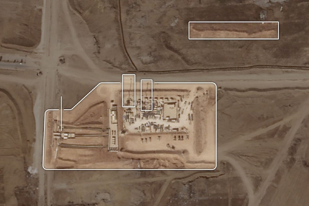
Satellite imagery of the expanding Israeli occupation base at the intersection of the Netzarim corridor in March. (Satellite image by Planet Labs via NYT)
In recent months, the Israeli occupation has strengthened its presence in central Gaza by building up bases and demolishing Palestinian buildings, indicating preparations for long-term control, according to Israeli officials and satellite imagery.
Since the war's early stages, Israeli forces have controlled the four-mile Netzarim corridor in Gaza, preventing displaced Gazans from returning north. Over time, this area has expanded into an 18-square-mile zone under Israeli control, according to the Israeli military and satellite image analysis by the New York Times (NYT).
In the past three months, Israeli soldiers have demolished over 600 buildings along the Netzarim corridor, seemingly to establish a buffer zone. Additionally, they have quickly expanded a network of outposts equipped with communication towers and defensive fortifications.
The expansion has fueled speculation about Israeli plans regarding Gaza's future. Occupation leaders have expressed their plans to maintain occupation over Gaza after the war, even though the present specifics seem unclear. On that note, military analysts affirm the analysis, detailing that such expansion in infrastructure could be part of the Israeli plan.
Israeli control over the corridor
The Israeli control over the corridor has given the occupation the freedom to travel across the enclave, keeping hundreds of thousands of displaced Palestinians in the southern part of the Strip. Lt. Col. Nadav Shoshani, an Israeli military spokesperson, said in an interview that in recent months, the Israeli military extended its presence over both sides of the corridor, which is around 4.3 miles wide and 4.3 miles long, making it easier for Israeli forces to control the area.
According to some Israeli ministers, the Israeli occupation should take advantage of its current presence in the Gaza Strip by paving the way for more Israeli settlements.
Read next: Gaza people 'will not stay here': Extremist IOF settlement group head
Netanyahu has allegedly ruled out the option for now. On that note, it is worth noting that the former Israeli settlement of Netzarim is now once again under Israeli control.
According to satellite images over the past three months, the New York Times' analysis concluded that the Israeli military occupation has at least 19 large bases throughout the area, along with dozens of small ones. Those come along with others built earlier in the war. However, the images have detected a clear accelerated pace in settlement building.
According to the report, many settlements are walled off, with barracks, access roads, and parking for armored vehicles.
Expansion of Israeli bases
Based on satellite imagery, the report explains that at the intersection of the Netzarim corridor and the main highway running north-south, one of the largest Israeli occupation bases has been expanding throughout the year - now containing extensive infrastructure, such as two communications towers and a large checkpoint.
At least 620 residential buildings, greenhouses, and other structures have been leveled from September 3 to November 21, according to the NYT.
11 of the videos were verified by the NYT, showing Israeli efforts to reshape the geography south of Gaza City. They were first published by Younis Tirawi, a Palestinian journalist who downloaded them from Israeli social media accounts.
In response to questions by NYT regarding the demolitions, an Israeli Colonel argued that the buildings were used by "Palestinian militants" as lookout posts and hiding places.

 4 Min Read


